1970s DIABLO LAKES DISRUPTION
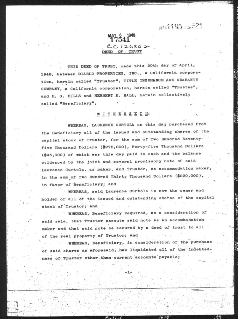
Larry Curtola in 1948 purchased the Diablo Country Club land, buildings, and unsold lots and significant vacant property and proceeded to move and shake to his heart’s content. He is widely recognized as the savior of the Country Club but is not often recognized for how he pushed for more and more development. Page one of his purchase of Diablo Properties, Inc. from Hills and Hall for $275,000 is shown below. The actual property parcel list was 41 pages long, covering 29 separate parcels.
For much of the 1950s Curtola whittled away at his holdings, selling what he could to residential buyers and some to other developers. Much of the infill as Diablo went from 50 to almost 400 homes happened on his watch and directly or indirectly benefitted him.
But it was the knock down drag out related to the Diablo Lakes development that really impacted anyone who frequents Mt. Diablo from the Southern Gateway side of the mountain, via Diablo.
Diablo Lakes Frenzy
This story begins with what some termed the upper 160 acres of Diablo, others refer to it as the Diablo Lakes area. Strategically this 193 acre property was the key connector to Mount Diablo for Diablo residents.
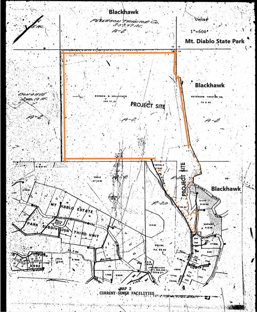
You gotta love these old maps and graphics. I took the map from the original EIR for Diablo Lakes and added the names Blackhawk (Peterson Tractor Co was essentially Blackhawk) and added the reference to Mount Diablo State Park at the top left and highlighted in orange the 193-acre parcel subject to development by Smiley and Curtola.
While the EIR was filed in the early 1970s Mr. Curtola and friends were quite active in the 1960s preparing for this eventuality. Recalling that the environmental constraints on developers were few in the 1960s and private land was deemed “I can do whatever I want here” the first order of business for Mr. Curtola was to deal with the Diablo Lake and Dam safety issues.
Here is a timeline of Curtola activities as recorded with the County and as this author has requested through Public Records requests.
1953 Recorded agreement to lease and or sell Diablo Country Club
1956 Recorded agreement to lease and or sell Diablo Country Club
1956 Recorded agreement to lease and or sell the water facilities known as Concord Irrigation Installation
1958 Recorded agreement to lease and or sell Diablo Country Club
Whether some of this recorded document activity was related to a mortgage on the Country Club property or whether it was just positive thinking related to an eventual sale, it is interesting that this process went on for years.
As it turns out the water facilities were not worth the money Curtola was asking. EBMUD was coming to Diablo in or around 1961 to upgrade infrastructure for the community and to allow for further new construction and lot split activity. The Country Club said no thanks to buying the Curtola Water Business.
So in 1961 Larry Curtola sold 115 acres of land back to the Diablo Country Club, divesting himself of this Club responsibility that he had purchased and improved. (LInk Below)
Diablo Lake/Reservoir/Black Hills Dam History
According to an article reflecting back on history and written in or around 1990, The Diablo Lake was built in or around 1880 and had a 50-foot-high dam and was 300 feet wide and 700 feet long. According to the Gazette it held 20 million gallons of water, enough to supply the city of San Francisco in 1880.
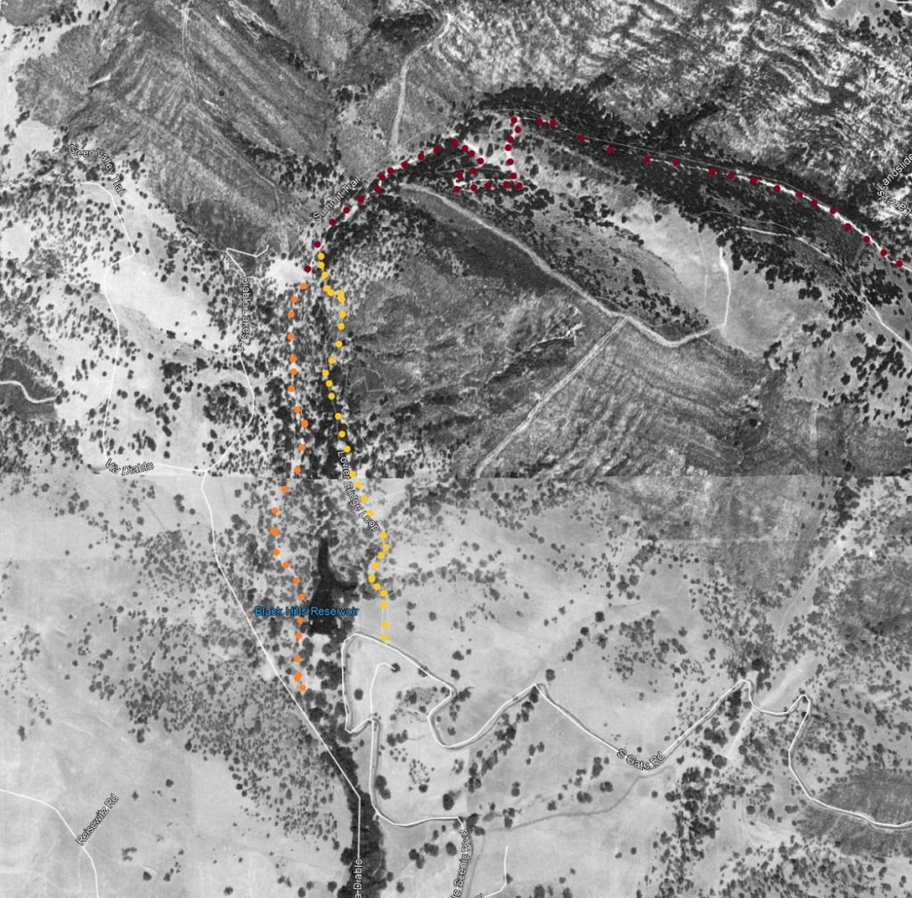
The labelled 1939 Google Earth image below shows what is called the Black Hills Reservoir, the Dan Cook Canyon Stage Road in dark red and the original extension of that Dan Cook Stage Road in orange down to Alameda Diablo skirting the left side of the Lake. The yellow dots show the 1959 Lower Bridge Loop trail that was protected as an easement until that property was acquired by the State in the 1980s.
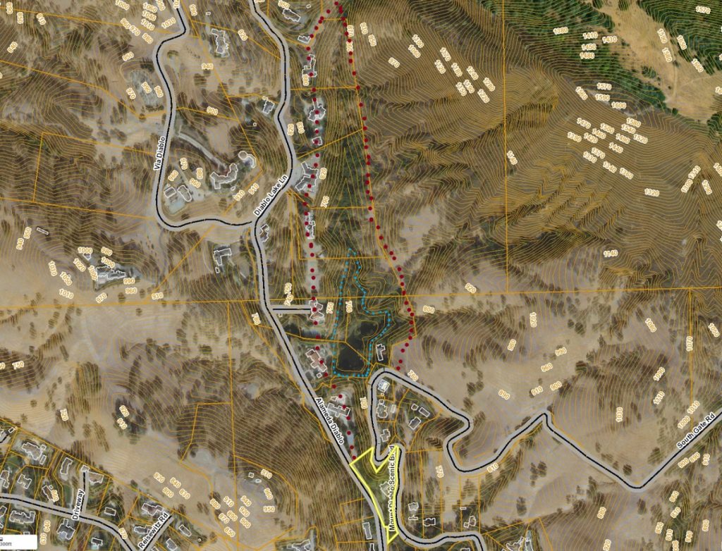
Below is a topo map of the Lake area showing the extent of a full reservoir behind a 50-foot-high dam within this drainage. The blue dots show approximate topo lines where water would collect and fill the canyon. The lower bridge loop easement is shown with dark red dots on the right and note that it loosely follows the Curtola property boundary for the entire distance. That makes sense because when the easement was recorded in 1959 the trail was built along the property line between Curtola and Blackhawk (Castle & Cooke). The dark red dots on the left show the old 1874 Stage Road before it was graded over and 6 residential housing pads created in its place.
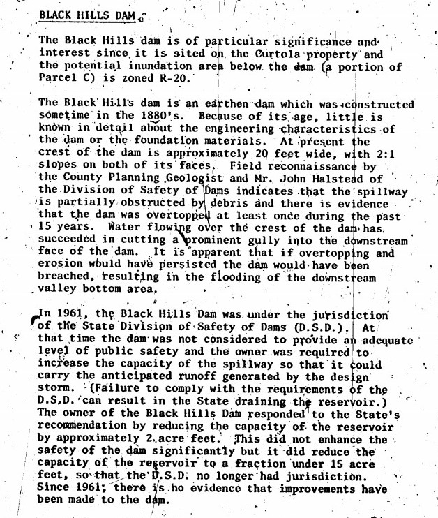
The EIR for Diablo Lakes provides us with some of the history of the Black Hills dam. It states: “in 1961 the Black Hills Dam was under the jurisdiction of the State Division of Safety of Dams (DSD). Since it had been over topped at least once in the previous 15 years the owner was required to increase the capacity of the spillway. Instead, the owner responded to the State’s recommendation by reducing the capacity of the reservoir by approximately 2-acre feet. Doing so did not enhance dam safety but reduced the capacity of the reservoir to a fraction under the 15-acre feet, so that DSD no longer had jurisdiction.” Further stating that as of this time (1975) there was no evidence that improvements had been made to the dam.
As a follow up, during the approval process for development of this property on March 26, 1975 the planning commission stated “The existing dam on Parcel B shall be removed or adequate spillways be constructed and all necessary repairs made.”
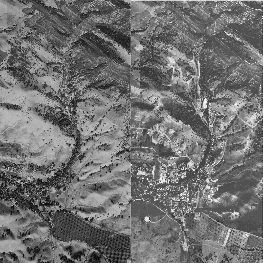
A 1968 aerial of this area shows how much grading and preparation for eventual housing stock was conducted in the 1960s, possibly under the excuse of needing to repair the dam (1961 requirement from the DSD.) This grading activity wiped out the first 1/2 mile of the 1874 Stage Road, literally wiped it out making way for house pads.
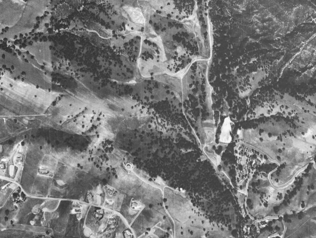
The local equestrian, hiking, and cycling community took notice of this earth moving activity. This new construction road (connecting Mt. Diablo Scenic Blvd. with Alameda Diablo) further restricted public points of access to the growing State Park. It bisected the original route followed especially by equestrians across the previously vacant flat lot below the dam that offered access to the 1959 Castle & Cooke riding and hiking trail easement.
This new construction road so close to the set of steep curves and blind corners leading to Mt. Diablo State Park was also dangerous. It handled slow moving heavy equipment and construction crews.
But what was the alternative? Taking all that construction equipment in through the center of Diablo? Some Diablo bridges are well under 20 feet in width and roadway width is limited to well below the recorded easement widths, not unlike Mt. Diablo Scenic Blvd.
For further perspective here is a closeup of a 1948 aerial and a 1968 aerial focused on the arrow of Mt. Diablo Scenic Blvd. In 1948 Diablo equestrians and hikers were still using the old Stage Road, the Lake was still a recreational part of Diablo life, and equestrians routinely rode up through the upper 160 to Dan Cook Canyon.
The 1970s development activity on this Upper Diablo Lakes 193-acre parcel was crazy. Below is a County attempt to provide some continuity to the vast number of lot splits and parcel maps
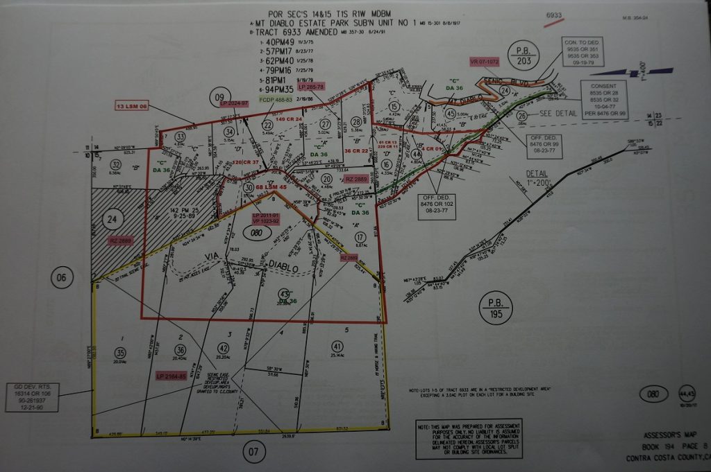
In fairness to equestrians and hikers this upper Diablo property was always private. Diablo residents had the best chance of using the old Stage Road or riding across the lower end of this property to the Lower Bridge Loop easement trail.
Old Diablo vs New Diablo
The society pages of the local newspapers loved to talk about Diablo and the wonderful parties and hikes and rides into and onto Mount Diablo. Like this one from the Okland Tribune 1956:
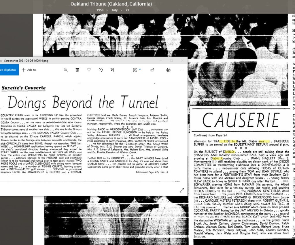
Further out in the country….the Gray Minors have dated a riding party and barbecue for Aug 25 near and about their Diablo home….ten couples bid to gather at Minor’s Camp (appropriate name given their home and grounds) shortly after 3 that afternoon for TRAIL RIDE into the Mount Diablo area…..BARBECUE SUPPER to be served on the EQUESTRIANS RETURN around 6p.m.
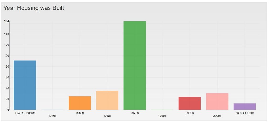
Diablo grew rapidly during the 1970s. This was infill growth. No mitigation was required (developer requirement to provide land or infrastructure improvements like bike paths or such). Some might argue that Diablo’s impacts on roads and the local surrounding community were never mitigated. The community received the public benefits from other developments in the area (Blackhawk comes to mind) but the growth from 50 to almost 400 homes within Diablo offered no forms of mitigation.
One might argue that what happened instead is the County recognized the importance of Diablo as the Southern Gateway to Mount Diablo State Park and protected as many of the original State Park points of access as possible.
The final Diablo Lakes lot split in this cascading set of splits and resplits set the stage for one final controversy, that of equestrian hiker and cyclist rights that are addressed in the next post entitled Today’s Diablo Park Access.
Here we discuss Kay’s Trail, the hole in the wall and the various easements and connectors between Alameda Diablo and Mt. Diablo Scenic Blvd.
1953 Recorded agreement to lease and or sell Diablo Country Club
1956 Recorded agreement to lease and or sell Diablo Country Club
1958 Recorded agreement to lease and or sell Diablo Country Club